
Cheaha State Park — A 1,200-foot Vertical Ecological Transect
We visited Cheaha State Park October 17-19, issuing two Great Blue Heron blog posts prior to this one: first my broad impressions then my musings on the Cheaha sky and clouds. I will focus now on an ecological transect as I hiked October 19, from Cheaha Lake (visible on the valley floor in the photo below) to the summit, passing up through the Rock Garden (the overlook location for the same photo) then on to the summit.
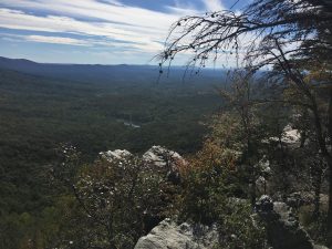
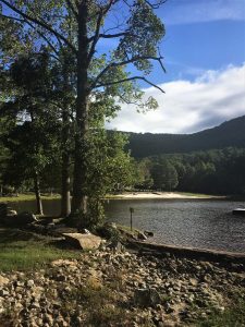
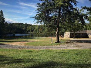
I learned long ago that a top-down-view always amplifies the elevation perspective. That is, looking down at Lake Cheaha seemed far higher than the lakeside view (below left) toward the ridges. The relatively flat terrain around the lake belied the steep topography awaiting me. Nature is like the layers of an onion. Peace and serenity greeted me when Judy dropped me at the lake. Who could ask for a more perfect 60-degree morning start? An RV campground and primitive camping are near the lake, yet I saw just one other person. The lower right photo shows a CCC-constructed building used now as a bathhouse.
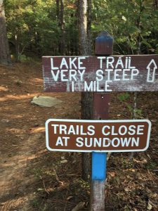
The relatively flat and fertile bottom-lands were soon to transition to, as the sign warns, a very steep one-mile ascent. I did not have the luxury of past land-use maps or a naturalist accompanying me. Nor did I take the time to scour the land to thoroughly read the signs of past-use. I presume that some portion of the valley saw tillage and certainly served as pasture. It’s hard to believe that over some 200-years of European settlement so many of these seeming remote nooks and crannies in the Appalachians (from here to Pennsylvania, New York, and into New England) saw intrepid pioneers scraping a living and sustenance from the land. However, even the boldest among them would not have attempted to plow or graze much beyond the trail head sign!
Aldo Leopold (A Sand County Almanac), “The only conclusion I have ever reached is that I love all trees, but I am in love with pines.” He mentioned the three species of pine native to Wisconsin, where he lived and wrote his signature book. I am teaching a Huntsville LearningQUEST (“informal education for adults of all ages”) course on A Sand County Almanac. I reflected on how many species of pine are native to The Heart of Dixie. As I write, I will try to name them, and then I will check my references to confirm, add, or subtract. I pledge to honestly assess my performance. Here goes: loblolly (Pinus taeda), slash (P. elliottii), longleaf (P. palustris), Virginia (P. virginiana), shortleaf (P. echinata), sand (P. clausa), spruce (P. glabra), and pond (P. serotina) pines. Before I verify, I want also to mention table mountain pine. I will not — I think it does not range naturally this far south. I’ve researched. I’ll begin with table mountain pine (Pinus pungens). From the US Forest Service: “its range extends from central Pennsylvania, southwest to eastern West Virginia and southward into North Carolina, Tennessee, and the extreme northeast corner of Georgia.” So, count me lucky on not including it as native to Alabama. All eight of the ones I listed are, in fact, native to Alabama. However, I am embarrassed at having missed the one that I did — eastern white pine (P. strobus), which is native to just five Alabama counties.
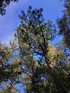
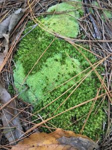
My lake to summit transect passed under four pine species: loblolly, Virginia, shortleaf, and a few longleaf around the lake and on the lower slope (below left). My forester friends up-north (and I don’t mean the Tennessee Valley region) have never encountered this signature species of the deep south. I hold its long needles, erect posture, and huge cones in high esteem. Its coarse broom-tipped upper branches stand out nicely against the early autumn blue. Its dropped needles accent the pine litter moss below right. Beauty and magic from tree crown to forest floor!
It’s perhaps inconceivable to readers that I could cherish both sourwood (Oxydendrum arboreum) and Longleaf pine. On one hand, longleaf pine’s indomitable negative geotropism (geotropism from my online default dictionary: “the growth of the parts of plants with respect to the force of gravity. The upward growth of plant shoots is an instance of negative geotropism; the downward growth of roots is positive geotropism.” The longleaf pine does not know from vertical! Ramrod straight, refusing to twist or bend to seek or secure more sunlight. Sourwood seems oblivious to Nature’s insistence that the law of gravity is universal. Instead, sourwood shuns even the theory of gravity, disdaining any thought of verticality. Still on the lower slope, I wanted to embrace this individual sourwood revolutionary (below), rejecting and rebelling against the predominant rule of law. Even I could have climbed this nearly horizontal arboreum. Odd that its Latin species name should suggest something more intent upon reaching into the canopy.
Why do I relish sourwood? First, I grew up well within its northernmost range in the central Appalachians. I liked its deeply-fissured bark, its fragrant spring flowers (makes great honey!), and its curvaceous form from which a two-by-four will never be sawn. I liked it, too, because once I departed for my bachelors degree in upstate New York, none of my fellow students knew my southern friend. Years later when I served for nine years on the Penn State forestry faculty, I often answered queries asking me to identify understory species I did not recognize with, “It’s a sourwood,” knowing full well that we were out of its range. So now back within its range, I enjoy encountering sourwood frequently. This specimen grows trail side on the lower slope.
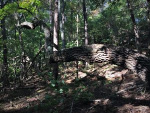
It’s adjacent to a 30-inch diameter chestnut oak (Quercus prinus), a massive specimen on a site richer than the shallow upper slopes where we most often find this species. See the sourwood escaping horizontally beyond the oak. The oak crown is fully dominant (lower right)… and has been for many decades. Perhaps reason enough for the gravity-defying sourwood to retreat at little more than 20 degrees above horizontal.
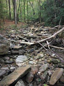
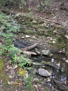
As I began ascending toward the very steep intermediate slope, the boulder-strewn dry stream-bed (below left) drew my attention. The trail paralleled the drainage-way, which obviously carries considerable and forceful flow on occasion. Appalachian-wide, these old mountains are products of erosion. They have long since lost their rugged, towering heights. From my ultimate (translates to lazy and convenient for the purpose of these blog posts) source of internet research, “Cheaha Mountain is part of the Talladega Mountains, a final southern segment of the Blue Ridge Mountains, unlike other elevations of the Appalachians in north Alabama, which are part of the Cumberland Plateau. The mountain is the highest point in the eastern portion of the Sun Belt (east of the Mississippi River, south of Interstate 20, and north of the Gulf of Mexico). Geologically it is composed of weakly metamorphosed sandstones and conglomerates of the Cheaha quartzite, of Silurian/Devonian age, and stands high topographically due to the erosional resistance of these rocks.” A bit further along, I found a trickle of water riding the exposed bedrock (below right).
I’ll venture an untested (by me) hypothesis: I’ll call it Steve’s 99:1 rule of landscape-scale erosion. Simply, 99 percent of erosional impact results from one percent of the storms. And among those impactful storms, think about the relative magnitude and erosional consequence of a hundred-year-storm. Or even more powerful, a thousand-year deluge. Water’s force operates logarithmically. Epic storms carved these valleys. I would like to return when this now-dry channel carries enough volume to tumble a few stones, yet I believe my chances are slim. Such first-order streams are not perennial. From the Geologic Society of America, “A first-order stream is the smallest of the world’s streams and consists of small tributaries. These are the streams that flow into and “feed” larger streams but do not normally have any water flowing into them. In addition, first and second order streams generally form on steep slopes and flow quickly until they slow down and meet the next order waterway.”
Of interest, the Mississippi River is a tenth order stream; the Amazon is twelfth order. The Geologic Society adds, “First through third order streams are also called headwater streams and constitute any waterways in the upper reaches of the watershed. It is estimated that over 80 percent of the world’s waterways are these first through third order or headwater streams.” Somewhat of a footnote, I successfully navigated an upper level undergraduate watershed management course and a graduate hydrology offering, both with three weekly lectures and weekly three-hour labs. I recall a weekend field trip in the graduate course to Hubbard Brook Experimental Forest (with its calibrated watersheds) in New Hampshire. Since then and perhaps prior to this formal education validation, I have been fascinated by weather and stream/watershed behavior. Four and one-half decades since that field trip, I am still captivated by watershed hydrology when hiking an Alabama mountain trail at Cheaha State Park.
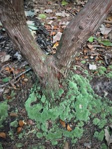
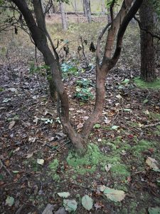
I soon climbed above drainage ways meriting a stream order rating. Rainwater from here and points above does little more than percolate into the thin soil and find its way among the rocks to the defined channels below. I turned my focus back to plants. Mountain laurel (Kalmia latifolia) seems quite content throughout its range finding purchase on shallow rocky soils. This specimen fits my image of its stereotypical site. Notice the mossy cushion at its base, the moss luxuriating from the incremental moisture (and accompanying nutrients) delivered via rainwater stem flow from the laurel. The same benefit accrues to the moss at the Virginia pine base (below right; beyond and to the right of the laurel). I see a few chestnut oak leaves under the laurel, yet another affirmation of thin rocky upper slope position.
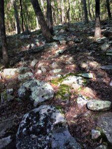
Steep stony rubble (moss and lichen adorned), upper slope position, lots of direct sunlight on the forest floor, an aspect facing southwest, and sparsely-stocked forest of small diameter in aggregate signal poor site quality. What I encountered differed little from what I expected.
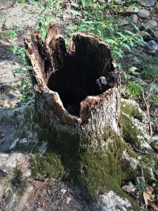
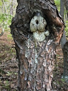
Likewise, I would not have expected healthy, vigorous individuals. I wondered how the hollow white oak (below left) stood as long as it apparently had, with only a thin band of intact wood ringing its base. It had only recently (within months) fallen across the trail. The Cytospora canker on the Virginia pine (below right) results from a fungal infection. Such target cankers weaken the stem and interfere with translocation. Yet, and I think such is the case with this individual, such fungi can co-exist with the host tree for decades. Perhaps the longevity in this case is owing to the poor site and the tree’s slow growth.
Aldo Leopold (A Sand County Almanac; November) spoke reverently of the tree disease/animal (from bees to birds to mammals) interdependency on his Wisconsin woodlot: “Soon after I bought the woods a decade ago, I realized that I had bought almost as many tree diseases as I had trees. My woodlot is riddled with all the ailments wood is heir to. I began to wish that Noah, when he loaded up the Ark, had left the tree diseases behind. But it soon became clear that these same diseases made my woodlot a mighty fortress, unequaled in the whole county.” He then devoted five pages to the nature of such ecosystem interplay.
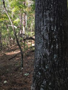
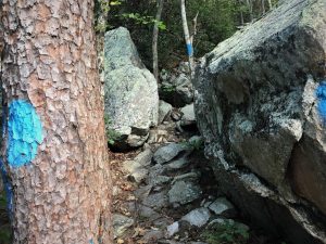
The mountain sheds boulders on its higher, steeper reaches. What are the mechanics of these relics from above? Have they rolled and slid downward from The Rock Garden ledges above? I think not. From my experience elsewhere, I’m led to believe these sometime house-sized remnants of the most resistant strata have actually weathered from vertically above, the softer stone weathered from beneath them. That is, these rocks have not slipped from current uphill positions, sliding down and outward, but instead have their origin directly above… an above that no longer exists. Regardless of their origin, they provided steps and handholds for my old-guy ascent, somehow steeper than these photos suggest. The Virginia pine with blue trail blaze (below left) must have had the good fortune of sinking roots deep into fertile soil nestled among the piled boulders. The tree has no equal nearby. The good tree-fortune of chance, fortuity, and serendipity.
![]()
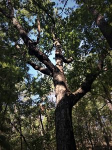
I suppose the same luck of the draw applies to this blazed red oak. An acorn just happened to find security, purchase, and sustenance lodged in the right boulder-pile fissure. To my knowledge trees have no intention and are absent a strategic plan. Instead, by evolutionary design, they produce enough acorns to advantage the chance (perhaps likelihood) that some such fortuitous site lies within reach of gravity, squirrel caching, or bluejay drop. And now, in duty to the species, this oak is producing acorns to secure the future of the line… and to do its part to biologically, chemically, and physically sustain this old mountain ecosystem. Meantime, in a tiny increment of the tree’s life, I hiked upward past it, pausing only to snap its photo and then lean against it to catch my breath. It served me well… without intent.
![]()
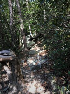
And ever upward into an area where serendipity furnished few high quality micro-sites. Still a forest, this stand is hard-scrabble. No sylvan-cove cathedral here. The bent and shattered Virginia pine (at lower left in the photo) evidences the ravages of a 2014 ice storm at this elevation. And I scrambled onward.
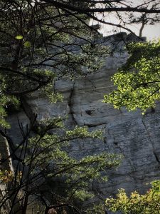
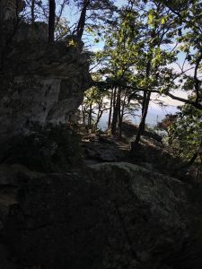
Suddenly a view from immediately below of The Rock Garden. Picture these nearly horizontal strata reaching out over Cheaha Lake. Time and the inexorable forces of Nature have weathered and transported many cubic miles of weakly metamorphosed sandstones and conglomerates to the Gulf of Mexico. I had taken the photo of the valley and lake at the beginning of this blog post the afternoon prior from atop this ledge.
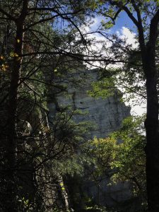
I found something special and moving in the dark silhouette of the rock backlit by the wispy cirrus.
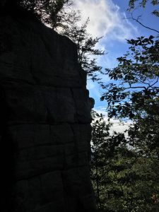
And I add this photo to demonstrate how tenaciously Virginia pine find purchase on the very ledge. Is the view wasted on them? Or do they simply appreciate the abundant, unimpeded access to the sunlight that fuels them? They have no need to strive vertically among competitors to secure full sun.
I insert that first photo. My reward for having traipsed ever-upward.
Thoughts and Reflections
I wrote my two books (Nature Based Leadership (2016) and Nature-Inspired Learning and Leading (2017)) to encourage all citizens to recognize and appreciate that every lesson for living, learning, serving, and leading is either written indelibly in or is powerfully inspired by Nature. Here are succinct lessons I can easily draw from this Blog Post:
- Individuals, enterprises, and society broadly must awaken to our obligation to wisely steward our environment – from within our local community to globally. The State Park speaks lucidly to this cause.
- Don’t be blind to what lies in front of you. “Vision is the art of seeing what is invisible to others.” (Jonathon Swift) I saw what I could on this Friday morning ecological transect. Yet I only scratched the surface of the stories unread and untold.
- Nature can serve as an essential life focus. Such is my own pursuit… my own life-chord. The snippets I read along a two-hour transect are essential notes in my chord.
- Nature provides multiple attractions for enhancing life’s journey. Why else would I be planning four GBH Blog Posts from a simple two-night/three-day immersion at Cheaha State Park?!
- Every life… every enterprise is interdependent with all else. While my perspective on every tree, rock, and dry stream bed may be mine alone, this one (among a thousand such transects just here on Cheaha) and I are part of something much larger and grander.
- Effective and fulfilling living, learning, serving, and leading require full doses of humility and inspiration. I could not view the sourwood/longleaf pine posture and form contrast and not feel humility or a deep sense of inspiration.
I have said often that Alabamans are blessed with Nature’s richness, including our 22 State Parks encompassing 47,000 acres from the Gulf Coast to the Tennessee Valley. I intend to continue my 22-stop journey… and share my travels, reflections, observations, and lessons from Nature with you.
Note: All blog post images created & photographed by Stephen B. Jones unless otherwise noted. Please circulate images with photo credit: “©2018 Steve Jones, Great Blue Heron LLC. All Rights Reserved.”
Another Note: If you came to this post via a Facebook posting or by an another route, please sign up now (no cost… no obligation) to receive my Blog Post email alerts: https://stevejonesgbh.com/contact/
And a Third: I am available for Nature-Inspired Speaking, Writing, and Consulting — contact me at steve.jones.0524@gmail.com
Postscript Cheaha Photo from the Official State Park Archives
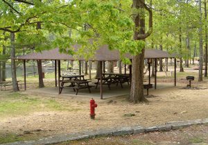
Picnic pavilion at Cheaha Lake, near the trail head where I began my ascent.